Text messages & smart phone apps alert Georgians of severe weather

Merritt Melancon is a news editor with the University of Georgia College of Agricultural and Environmental Sciences.

For decades families have relied on NOAA weather radios to alert them to hazardous weather conditions near their homes. Updates in technology now give the public options for staying abreast of weather conditions while on the go.

Dozens of smartphone apps and mobile phone alert services now allow you to track storms and receive emergency alerts even if you’re away from your weather radio or TV.

“People should definitely have some kind of notification that can provide them with warning of incoming severe weather when they are outside away from television,” said University of Georgia agricultural climatologist Pam Knox.

Knox notes that while many communities maintain emergency alert sirens, people may not always be where they can hear the sirens when an emergency strikes – especially if they live in a rural area.

Since most people keep their phones with them — while in the car, in the garden or on a hike. These news apps and services can provide life-saving advanced notice when a storm is approaching, Knox said.

The new apps generally fall into two categories: alert services that send texts or emails to subscribers when severe weather is on the horizon and apps that use push alert notifications (whistles, buzzers, sirens) to inform you of bad weather based on your current location.

Alerts by text

Many municipalities and counties are using text alert systems, like Nixle, to alert the public to everything from icy roadways and serious traffic accidents to missing people. For the most tailored information, mobile phone users may want to check with their local police or fire departments for information on local systems.

Mobile phone users may also receive wireless emergency alert text messages through their cell phone provider. These are alerts sent out locally by the National Weather Service and local emergency management personnel. Phone users should check with their carrier to configure their phone to accept these alerts. Visit www.ctia.org/wea for more information on the system.

Paid services are also available to deliver emergency alerts to cell phones via text. Free services are provided by commercial weather services like The Weather Channel, which delivers daily forecasts.

Cell phone users can also sign up for a wide range of text alerts from FEMA. Most deal with disaster preparedness, helping people find shelter or assistance after a disaster strikes. Subscribe now at www.fema.gov/text-messages to be prepared for severe thunderstorm and tornado season.

Weather alert apps

The second option for using your cell phone as an emergency alert device is to download one of the many available weather alert apps. There are several options to chose from at the Apple’s App Store and Android’s Google Play.

Accuweather.com, The Weather Channel, Ping4alerts, Weather Underground and The Red Cross offer free apps that will cause cell phones to buzz, ring or vibrate when the National Weather Service issues a severe weather alert.

The Red Cross alert apps are event specific. They send out audible alerts only when tornado or hurricane warnings have been issued. Due to their serious nature, these alerts are sent more infrequently. Red Cross apps also provide disaster preparedness and recovery information.

Advanced weather and emergency apps are available for a fee. Topping the list at the high end are apps like Radar Scope, which for $9.99 provides real-time, highly-detailed weather radar images, to NOAA Weather Radio, which for $1.99 provides audible National Weather Service alerts and reports the closest lightening strike in your area.

While most weather apps pull their information from the National Weather Service, none were created by the service. NWS does maintain a list of suggested mobile products at www.weather.gov/subscribe and operates mobile.weather.gov, a version of its website that is optimized for smart phones.

NOAA has a series of apps for both iPhone and Android phones, but most address wildlife issues and marine conditions.

Tech savvy individuals can read instructions on how to use your mobile device to prepare for disaster at www.redcross.org/prepare/location/home-family/tech-ready/data. For information from UGA Extension on how to prepare for natural disasters, visit extension.uga.edu/environment/disasters.

Insects and Cold Weather

Vector of West Nile Virus

Elmer Gray, University of Georgia, Entomology Department

With this winter’s unusually cold temperatures, the question of how these conditions affect insects is sure to arise. It is of little surprise that our native insects can usually withstand significant cold spells, particularly those insects that occur in the heart of winter. Insect fossils indicate that some forms of insects have been in existence for over 300 million years. As a result of their long history and widespread occurrence, insects are highly adaptable and routinely exist and thrive, despite extreme weather conditions. Vast regions of the northern-most latitudes are well known for their extraordinary mosquito and black fly populations despite having extremely cold winter conditions.

The question then arises, how do insects survive such conditions? In short, insects survive in cold temperatures by adapting. Some insects, such as the Monarch Butterfly migrate to warmer areas. However, most insects use other techniques to survive the cold.

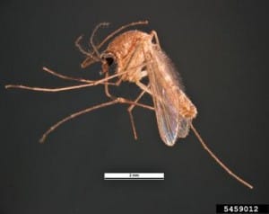
Vector of West Nile Virus
Southern House Mosquito, Pest and Diseases Image Library, Bugwood.org

In temperate regions like Georgia, the shortening day length during the fall stimulates insects to prepare for the inevitable winter that follows. As a result, many insects overwinter in a particular life stage, such as eggs or larvae. Many mosquitoes overwinter in the egg stage, such as our common urban pest the Asian Tiger mosquito (Aedes albopictus), waiting for warmer temperatures and sufficient water levels to hatch in the spring. Another technique is to take advantage of protected areas, as do adult Culex mosquitoes overwintering in the underground storm drain systems. Other insects overwinter as larvae or pupae in the soil, protected from the most extreme temperatures. However, this still doesn’t answer how insects survive freezing temperatures, only to become active as warmer temperatures return.

All insects have a preferred range of temperatures at which they thrive. As the temperature drops below this range the insects become less active until they eventually cannot move. A gradual decline in temperatures, coupled with a shortening day length, serves to prepare an insect to tolerate freezing temperatures. Several factors are important to this tolerance.

The primary thing that an insect has to avoid is the formation ice crystals within their body. Ice crystals commonly form around some type of nucleus. As a result, overwintering insects commonly stop feeding so as to not have food material in their gut where ice crystals can form. This reduction in feeding will also result in a reduction in water intake.

A degree of desiccation increases the concentration of electrolytes in the insect hemolymph (blood) and tissues. In addition, insects that can tolerate the coldest of temperatures often convert glycogen to glycerol. These electrolytes and glycerol create a type of insect antifreeze. This will lower the freezing point of the insect to well below freezing, a condition described as supercooling. When this occurs, the insect can withstand extremely cold temperatures for extended periods.

However, at some point insects will suffer increased mortality, possibly due to desiccation, toxicity or starvation. Nevertheless, insects are well adapted to survive freezing temperatures, especially after a few 100 million years to perfect their systems. It is generally assumed that introduced pest insects from sub- and tropical areas would be more susceptible to extended cold spells, but depending on their ability to find local refuges and their numbers and adaptability, they likely will remain viable and persist as pests as well.

In summary, entomologists don’t expect the cold winter to have a significant impact on insect populations this spring. Local conditions related to moisture and overall seasonal temperatures (early spring/late spring) will play a much more important role in insect numbers as we move from winter to summer and prepare for the insects that will be sure to follow.

Cool wet summer will probably be followed by dry winter with temperature swings

Pam Knox, Agricultural Climatologist with UGA Department of Crop and Soil Science

In the last 12 months Georgia saw the tale of drought and one of the wettest springs and summers on record. Then abnormally dry conditions returned. 2013 has been a climatic roller coaster to say the least.

Overall, the above-normal rainfall delayed planting, prevented farmers from getting into their fields and increased some fungal diseases and pests. The rain did result in lush growth, but persistent cloudiness across the state also delayed crop development once they were established.

As the rainfall diminished in the fall, abnormally dry conditions returned to some parts of the state as the growing season came to a close. This caused grazing pastures to turn brown earlier than usual.

A year for the record books

Several stations in the state accumulated noteworthy rainfalls this growing season, measured during the seven-month period from May through October.

Most notable was Macon, which had its third wettest April to October in 122 years of record keeping, with 41.71 inches. Climatologists had to go back to 1928 to find a wetter growing season. That year climatologists reported 42.89 inches during the same period.

Macon is also currently setting a record for year-to-date rainfall with 60.45 inches, ahead of the 59.88-inch record set in 1929. Macon also had its fifth coldest summer this year, due in part to the cloudiness and rainy conditions.

Atlanta experienced its fourth wettest year, in the 136 years that people have been keeping records, with 39.37 inches. The last time Atlanta received this much rain was in 2009 (40.87 inches), which included the significant flooding event of September 2009 that affected much of the Atlanta metropolitan area.

Columbus reported its fourteenth-wettest growing season in 66 years of record. However, it is interesting to note that Columbus experienced three of its five wettest growing seasons in the last decade — in 2003 (fourth), 2005 (third) and 2009 (second).

Drier times return

Despite this summers’ rains, conditions have become much drier across Georgia this fall, and abnormally dry conditions returned to a significant part of Georgia for the first time since April. The National Weather Service cooperative observer in Warrenton (Warren County) reported no precipitation in October. This was the driest October they have had in 100 years of record.

The Climate Prediction Center of National Oceanic and Atmospheric Administration (NOAA) predict these drier than usual conditions will continue through the next few months. The highest chance of dry conditions is in southern Georgia, stretching south into Florida.

No El Niño or La Niña, so expect lots of fluctuation

According to NOAA, there are equal chances for above, near or below normal temperatures through the winter.

One reason this trend can be projected is the current status of the El Niño Southern Oscillation (ENSO) is neutral, which means that neither an El Niño nor La Niña is likely to occur this winter. These neutral ENSO conditions are expected to continue until at least next summer.

In neutral ENSO conditions, Georgia does not experience a strong trend toward above or below normal rainfall or temperature. However, the state does tend to experience large swings in temperature between warm and frigid conditions. The chance of a late frost in the spring following a neutral winter is increased, although still relatively rare.

If we experience a warm spell in early spring, gardeners and farmers are likely to want to get started planting early to take advantage of the warm conditions. However, the increased chance of a swing back to cold temperatures, and the potential for frost, should make them proceed with caution. Watch the weather carefully before starting the planting process.

For more information see November’s lows and highs are a preview of winter’s weather 

Cool wet summer will probably be followed by dry winter with temperature swings

Pam Knox, Agricultural Climatologist with UGA Department of Crop and Soil Science

In the last 12 months Georgia saw the tale of drought and one of the wettest springs and summers on record. Then abnormally dry conditions returned. 2013 has been a climatic roller coaster to say the least.

Overall, the above-normal rainfall delayed planting, prevented farmers from getting into their fields and increased some fungal diseases and pests. The rain did result in lush growth, but persistent cloudiness across the state also delayed crop development once they were established.

As the rainfall diminished in the fall, abnormally dry conditions returned to some parts of the state as the growing season came to a close. This caused grazing pastures to turn brown earlier than usual.

A year for the record books

Several stations in the state accumulated noteworthy rainfalls this growing season, measured during the seven-month period from May through October.

Most notable was Macon, which had its third wettest April to October in 122 years of record keeping, with 41.71 inches. Climatologists had to go back to 1928 to find a wetter growing season. That year climatologists reported 42.89 inches during the same period.

Macon is also currently setting a record for year-to-date rainfall with 60.45 inches, ahead of the 59.88-inch record set in 1929. Macon also had its fifth coldest summer this year, due in part to the cloudiness and rainy conditions.

Atlanta experienced its fourth wettest year, in the 136 years that people have been keeping records, with 39.37 inches. The last time Atlanta received this much rain was in 2009 (40.87 inches), which included the significant flooding event of September 2009 that affected much of the Atlanta metropolitan area.

Columbus reported its fourteenth-wettest growing season in 66 years of record. However, it is interesting to note that Columbus experienced three of its five wettest growing seasons in the last decade — in 2003 (fourth), 2005 (third) and 2009 (second).

Drier times return

Despite this summers’ rains, conditions have become much drier across Georgia this fall, and abnormally dry conditions returned to a significant part of Georgia for the first time since April. The National Weather Service cooperative observer in Warrenton (Warren County) reported no precipitation in October. This was the driest October they have had in 100 years of record.

The Climate Prediction Center of National Oceanic and Atmospheric Administration (NOAA) predict these drier than usual conditions will continue through the next few months. The highest chance of dry conditions is in southern Georgia, stretching south into Florida.

No El Niño or La Niña, so expect lots of fluctuation

According to NOAA, there are equal chances for above, near or below normal temperatures through the winter.

One reason this trend can be projected is the current status of the El Niño Southern Oscillation (ENSO) is neutral, which means that neither an El Niño nor La Niña is likely to occur this winter. These neutral ENSO conditions are expected to continue until at least next summer.

In neutral ENSO conditions, Georgia does not experience a strong trend toward above or below normal rainfall or temperature. However, the state does tend to experience large swings in temperature between warm and frigid conditions. The chance of a late frost in the spring following a neutral winter is increased, although still relatively rare.

If we experience a warm spell in early spring, gardeners and farmers are likely to want to get started planting early to take advantage of the warm conditions. However, the increased chance of a swing back to cold temperatures, and the potential for frost, should make them proceed with caution. Watch the weather carefully before starting the planting process.

For more information see November’s lows and highs are a preview of winter’s weather